Aviation Meteorology
Western Disturbances
On the global charts, one can see eastward moving troughs in the zonal westerlies. These upper air troughs in the sub-tropical westerlies often extend down to the lower troposphere of the northern latitudes of the Indian sub-continent, particularly during the winter season. These often give rise to closed cyclonic circulations on the sea level charts. In Indian Meteorological terminology, these have come to be known as Western Disturbances (WDs).
Origin and Movement
The westerly trough or waves and the associated low level cyclonic systems often originate in the West Atlantic or Mediterranean regions. These are of the extra-tropical frontal type of cyclones. Secondaries develop over the Persian Gulf. The mountainous terrain of Iran, Afghanistan and Pakistan modifies and often obliterates the frontal characteristics of the systems at the lower levels.
The movement is east or northeastwards.
Incidence
These disturbances affect mostly north-western Indian and the Himalayan belt. They come farthest south in mid-winter. They occur most frequently in winters. During monsoon, WDs have a track northeastwards, thus taking them north of India.
Characteristics
In the Indian region, these disturbances are mostly in an occluded stage, though sometimes well-marked lows or depressions with the characteristic warm front, warm sector, cold front and the associated weather moving from west to east can be clearly discerned. The movement can be clearly traced on the charts from West Asia onwards. Sometimes, no surface low can be drawn on the charts
but the weather system can be seen progressing eastward. However, in such cases the progression of well-defined upper air waves can be seen.
Orography plays a major part in the breaking up, stagnation and intensification of these disturbances. Some of these disturbances split into two in the hilly regions of Pakistan, one moving north and the other eastwards. In the western Himalayas over J & K and Himachal Pradesh areas, some of the disturbances break up and dissipate while some take a more easterly course and travel as far east as Assam and North Burma. A depression located in the coastal region, west of the Nile may move east northeastwards and affect north Iraq, Iran, Afghanistan, Northern Pakistan and Kashmir. Many of the depressions moving over Iraq separate into two near the Iraq-Iran area due to the obstruction of the high terrain there. The northern cell moves northeast over Iran and the southern cell travels east along the Persian Gulf. The southern cells intensify over the Persian Gulf area though they weaken further east since the circulation in the lower levels is cut off over the highland regions of Iran, Baluchistan and Afghanistan. Hence, by the time they cross over to India, they are mostly weak and irregular
disturbances.
Over northwest India they revive and intensify again with moisture fed from the Arabian Sea. Depressions which take a more southerly course often enter Indian peninsula along the Mekran coast, sometimes developing warm and cold fronts, the contrasting air masses being the moist, warm Arabian Sea current and the cold, dry north/northwest winds from the temperate regions. The nearly closed character of the Punjab with high hills to the north, northeast and west and the open terrain to the east and south explains the tendency of western disturbances to slow down and intensify in this area.
Weather Sequence
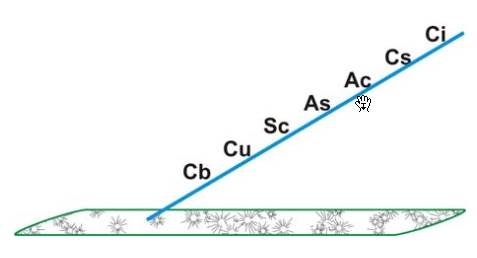
The approach of a western disturbance is indicated by the gradual fall of pressure and rise in temperature. The winds, both at surface and upper levels, back and acquire a southerly component. Extensive clouding also appears. Fig indicates the cloud pattern. The sequence of clouds is: cirrus, cirrostratus lowering to altostratus. Some small amounts of stratocumulus, cumulus and cumulonimbus also develop. With the advent of the cold front, large cumulonimbus develops over a relatively narrow belt. Continuous light rain or drizzle occurs over an extended area with the warm front while intermittent rain or scattered showers are experienced in the warm sector.
Heavy showers of short duration sometimes accompanied by thunderstorms or hailstorms and squalls are characteristics of the weather during the passage of the cold front. In the hills, sleet in the beginning of the season and
snowfall later replaces the rain or showers of the plains.
Weather clears up with passage of the disturbance, with a sharp rise in the pressure and appreciable fall in temperature. In the wake of a disturbance, cold dry continental modified polar air sets in, causing a cold wave. Immediately after the passage of the cold front and prior to the setting in of the strong continental Northerlies, conditions are favourable for the occurrence of radiation fog. With skies clearing up overnight enabling prolonged radiation, temperature drops and the humidity is still high after the precipitation. The fog while lifting up often gives rise to low stratus persisting for two to three hours after the dissipation / lifting up of fog.


